|
150 Mile Color
Tour
This tour takes you to some of the most
spectacular scenery this country has to offer. You
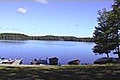
start in Ontonagon. Take M64
along the shore of Lake Superior to the West all
the way to "Lake of The Clouds" on Hwy M-l07.
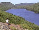
Next take South Boundary road south. Along the
way stop at the Visitors Center. Summit Peak is a
great lookout for colors. At the end of South
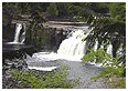
Boundary Road is Cty Rd 519. Go north for 1 mile
and get out of the car and walk to the waterfalls.
There is a boardwalk along the river to the shore
of Lake Superior.
Go south to Wakefield on 519 to Hwy 2. Turn left on Hwy 2 heading east. As you
travel this road you are driving through the heart
of the Ottawa National Forest.
There are several side roads you can travel.
Maps are available at the Forest Service offices.
At the intersection of Hwy 2 & 45 turn north.
In Paulding you will see the signs for Bond
Falls. This is a good spot for a stop. After Bond
Falls you can continue on this road to Hwy M28 the
second portion of this road is a good gravel road.
Or return to 45 and continue north.
If you continue you will intersect M28 go east
and stop at Agate Falls if you like. At the
intersection of M28 & 45 go north back to Ontonagon.
This tour is a full day so take plenty of
film.
|